Caribou Pond (Valley) Road, AT trail to South & North Crocker, Bushwhack attempt to Redington
Caribou Pond Road is in great shape until bridge number three. The third bridge is a little sketchy. I got out of my car and stared at it for a while before deciding to cross over it. After the third bridge, Caribou Pond Road is in rough shape. It is rutted and there is one large, deep pothole on the right hand side. Keep an eye out for it as you continue down the road. I’ve been on much worse roads and (unless you fall into that pothole) you shouldn’t have any problem driving to the parking area.
The parking area is a small dirt lot with room for about 10 cars. Surprisingly, there is very good cell reception in the lot. I chatted online with another hiking friend and checked in with my family before turning in for the night. I setup my ‘sleeping quarters’ so I could watch the sky through my car windows as I drifted off to sleep.
I woke up at 4:30, stepped out of my car and put my sandal-clad foot directly into a nice fresh pile of human excrement. My sandals spent the 4 hour drive home on the roof of my car. After I got over the horror, I set off on my hike.
To get to the trailhead, walk past the gate and follow the logging road for about a ½ mile. The trailhead is marked with a small cairn partially overgrown on the righthand side. The coordinates, for the trailhead, are N45 02.374 W070 20.677.
The first mile of this hike is relatively flat. After reaching the tent-site, the incline starts and the trail becomes moderately steep. For a short time the trail opens up onto a nice rocky area with great views but quickly moves back under tree cover. The summit of South Crocker is underwhelming, just a sign in the middle of the woods.
The connecting trail between the two Crocker mountains is relatively easy. You descend approximately 300 feet of elevation and then ascend approximately 500 feet of elevation to reach North Crocker. It would have been easier if I didn’t have to do it twice. When I got back to South Crocker, I realized I left my GoPro in a tree on the summit of North Crocker.
When I returned to South Crocker a second time, the weather had turned from a few clouds to complete cloud cover and light rain. I have to admit bushwhacks in iffy weather make me nervous. I started toward Redington and continued until I was a little over a 1/2 mile away from the summit. I just wasn’t feeling it. I kept questioning myself, "If I get lost and the weather continues to worsen, am I ready to spend the night?" My answer was 'hell no' and I decided to turn back.
I got lost anyway. It was the first time I’ve been lost in the woods in a long time. The last time was in 2014 during my Paugus Hell Hike. I’m glad this time l was lost for only 15-20 minutes.
Beginning of the bushwhack to Redington
I don't think it is a difficult trek to Redington, but it is easy to get turned around. The photo below is where I missed the turn to go back into the woods. Remember this fallen tree when you come out of the woods and onto the Yellow Blazed AT trail. Now instead of 8 left on my NE67, I have 9. But I'm in no hurry, I want to savor these last few adventures.
 |
| Open area on the way to South Crocker |
 |
| AT trail marker |
 |
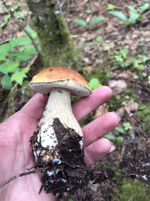
| Boletus edulis - a choice edible mushroom |
 |
| Sugarloaf in the background |
 |
| Immature Chanterelle mushrooms, another good edible |
 |
| herd path to Redington intersects with AT trail |
 |
| Another photo of Boletus edulis |
 |
| Yep, had to climb this summit twice |


No comments:
Post a Comment