I packed my bag and was ready to go until my husband noticed
there was a trail of small ants walking to and from my pack. OMG, I screamed. Ants and I have a long history and none of it good. I don’t like them and they don’t like me.
I tore apart my pack, took out all of my granola bars and gave any I thought were compromised to my husband.
He would eat them.
I repacked it and I put it on. My pack is heavy, OMG heavy. I felt like Cheryl Strayed.
I’ve been on the Davis Path before when I hiked Mt.
Crawford. No surprises here. Loose rocks, sandy dirt trail, eroded in
places and steep. Halfway up the trail I reached in my pack for some granola bars…
not there! I forgot to put the ‘uncompromised bars’ back in my pack. I had
nothing in my pack except for the meal I planned to cook on Stairs.
Okay, what did I have? I had some orange juice in my pack. It gave me
much needed energy to continue. I scanned
the ground for edibles. I found an
Indian cucumber, one half-ripe group of bunch berries, a lot of half-ripe
blueberries and ate old Trillium leaves the entire way up.
 |
| Trillium and Indian Cucumber |
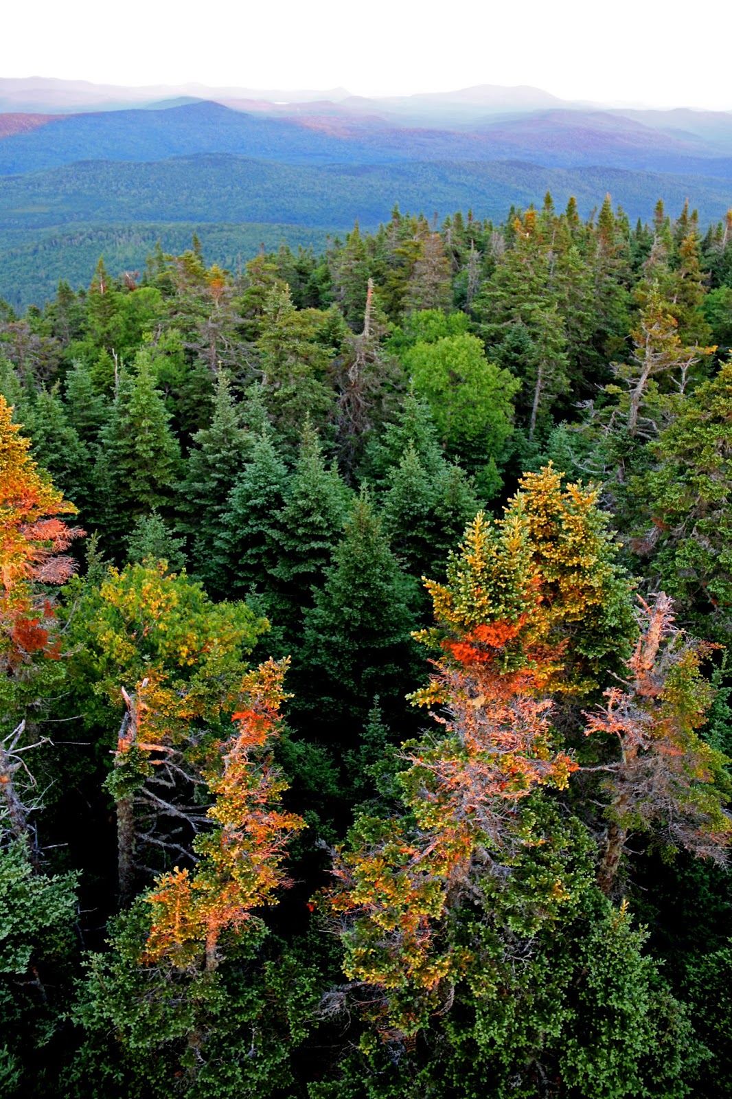
Two years ago while sitting on top of Crawford, I looked across
at Stairs and wondered how the heck do you get over there? I had visions of hiking deep into the valley
and then straight up Stairs. This is not
the case. The hike to Crawford is the steepest part of the entire hike. The Davis Path trail (it continues to the
right of Crawford trail) is a beautiful, meandering, peaceful, less-traveled, remote
wilderness trail. This portion of the trail
was my favorite part.
I continued to scan the ground for wild edibles and missed
the Parker Trail to Mount Resolution.
This inattention added 45 minutes to my hike. The Parker trail is eroded, overgrown, poorly
blazed, with a number of small blowdowns.
When the trail opened onto the first set of ledges I had to take a
minute to figure out which way to go. The
views were beautiful. The trail
continued through low brush, and opened up onto another set of ledges with
beautiful views. A number of trail logs
say there is a bushwhack to the summit of Mount Resolution. My idea of bushwhacking is obviously very different from theirs. A mild push through some brush is an
overgrown trail, not a bushwhack. So, I
was looking for a bushwhack.
My GPS registered 361 feet to the summit so I kept walking trying
find the best place to bushwhack to the
summit. I continued on until it said 168
feet away. I couldn’t imagine there was a view in this mess of trees, but I pushed
through the trees with my all my gear, pine needles flying everywhere, branches
snapping, spiders landing on my face, until my GPS registered 2 feet. I looked down and there was a small
rock. No views, just a rock. I am surrounded by a dense thicket of god
forsaken pines. I am being touched on
all sides, there is nowhere to move. A
wave of pure panic floods through me.
Claustrophobia. Definition: an extreme or irrational fear of confined
places. It took everything I had to
shut it down. I pushed through, got
out. Only 100 feet but it felt like
forever.
Still trying to get my heart rate down, I sat on the qualifying summit and took a selfie.

51
down, 1 to go.
I got back on the Davis trail, I was hungry and tired of Trillium
leaves. I drank some more orange juice.
I expected some real scrambles to get to the top. I expected Carter’s
Ledge, or South Baldface. Nope, just a
few rocks to climb over. If the ERD was
with me he wouldn’t have had any trouble darting up them.
I quickly get to the Stairs trail. There is a nice, easy to see, trailhead and tent
site sign here. It is a short, beautiful,
trail leading you to the Stairs. There
is only one problem. I’m not the only
one there.
I hear grumbling and talking. I see it’s one person talking to themselves. I’m disappointed. I wanted to be alone on the summit. My last hurrah alone. Oh well, I’ll make the best of it.

I set up my tent, made fire and cooked my food. I was ready to spend the night on Stairs.
We talk a bit, I can see he has some problems. He has
difficulty speaking. But we all have
struggles. Then the conversation took some turns.
I’m in pain a lot, my back. I’m on morphine for my pain.
Oh..
I grew up in group homes, they’re
worse than jail.
I felt sad for him.
We talk about hiking.
I have to walk everywhere; I had
to sell my car. My wife has my kids, she
couldn’t handle my addiction.
Oh.. Where do you live?
I’m homeless.
What do you do in the winter?
Homeless shelters don’t want me. They are worse than jail. I try to stay out
in the woods. This guy let me live with him
for a while, he wanted to have sex with me (he explains what kind). But
I’m not gay, at all, so you know.
Oh… uhm… oh
Then I had a job but the guy
fired me. He said I scared him. I get so angry from the pain. I frightened his customers. He let me go.
Now I’m here.
Oh… What do you do when you get angry?
I get so angry, I have to get away from people. I scare myself.
Oh... Well hiking is good for that.
At no point did I feel threatened
or frightened. He is a person, alone, trying
to climb out of a downward spiral. But I
didn’t know him or the depth of his history.
I didn’t know what his anger triggers were. I made him some bacon and pancakes, gave him
some canned milk and a packet of Starbucks coffee. I made the decision to go down.
He didn’t want me to go. He wanted the company and needed someone to
talk to. He wanted me to stay. I told
him my husband was uncomfortable with me staying on the mountain, alone, with
another man.
Wouldn’t you be worried if your wife was on the mountain with
another man?
I would be glad if she was lost alone on a mountain.
Well, I mean, if you liked your ex-wife, wouldn’t you be worried?
I guess. But
now I’m going to worry about you hiking down in the dark.
Thank you. Don't worry, I'll be fine. Be well, enjoy your sunrise tomorrow.
I packed my gear and headed
down as the sun set.

Another one of my fears,
besides being trapped in a sea of claustrophobic trees, is hiking in dark,
unfamiliar woods. Now I had 5 long miles
to descend, in the dark. I was
surprisingly comfortable on the narrow trails with my headlamp facing down, on
the trail ahead. There seemed to be safety in the confinement of the narrow
trail. I watched spiders scurry and slugs
slime their way across in my lamplight. I continuously had to brush away dozens
of small white moths, attracted to the light, off of my face. Their eyes reflected a shimmery gold as they
darted past. They looked like fairies. It felt alien and beautiful.
A few times the lamp created
fast moving shadows from branches on the trail.
I’d jump and squeak like an injured rabbit but quickly composed myself
and continued on. The only time I really
felt the ‘lizard brain’ jitters was when the trail opened up onto sprawling ledges.
I felt vulnerable from all sides. White blazes reflected the light from my head
lamp leading the way. Every time I saw
one, I wanted to hug the person who painted them!
At mile four I was tired and
had to resist the urge to go faster. The
last mile of the trail is pebbled sand with loose rocks just waiting for an
errant step. I heard rustling, I stopped short and stared into the woods,
looking all around, ‘lizard brain’ active again. Then I heard the barred owls, a group of
them, whooping it up with their happy calls.
I joined in, they called back welcoming me into their song. They stayed with me until I reached the car.
A beautiful end to a wild
ride.
And then there were none.
 |
| Parker Trail |


 |
| the turnoff to the Parker Trail, the one I missed |


 |
| Mount Resolution views |

 |
| my fire setup ready to go |
 |
| Chickens (of the woods) Laetiporus cincinnatus found too late to eat. |
 |
| another use for my flint striker |
 |
| Sauteed trillium leaves, pancakes, and bacon |
 |
| making faces on blue-staining boletes :) |
 |
| lovely garter snake along the trail :) |
 |
| sunset on Stairs |

 |
| the tent before the takedown |

 |
| Someone did some damage to this sign |
 |
| Fire prepped ready to be set. |
 |
| I made it :) |