I decided to find a place to stay to save me the morning
drive to Mt. Tom. Based on the price and
the last minute availability, I knew the room wouldn’t be a palace but I didn’t
expect to be assaulted by a cloud of dust and a room full of moose motif when I
opened the door. I took off the spread,
opened the windows and grabbed my emergency blanket from the car. I would be sleeping on top of the sheets tonight. When I got into bed I was immediately sucked
down into a black hole of sagging mattress.
Cute in the photo but unclean sheets and dust everywhere took away any cuteness.
I got up, packed my gear, happy to be leaving that room and heading
off to Tom. I was surprised to see the
parking lot hadn’t been plowed. When I
hiked Field last winter the entire lot had been cleared. Today I had to park on the side of the road.
The rain washed away a lot of the snow and turned some of
the lower trail into a muddy mess. Most of the trail was packed snow but some areas, that looked solid, actually had running water under it.
an earlier hiker must have had wet feet after postholing here.
There are a few water crossings. The first
two can be a little tricky but you can get across without getting wet. The second one is only tricky because the
rocks move when you step on them. The
rest are small easy walkovers.
There were lots of hikers on the trail today. I chatted with a few and got to meet “Emerel” and “Franko” who frequently log their
hikes on NE Trail Conditions. It’s
always nice to connect a face to a trail log.
As I approached the summit, three very boisterous hikers
came up behind me. They were nice but definitely
not quiet. Although there wasn’t a view
on the summit today, I was hoping to have a few minutes of solitude and a brief
yoga practice. Since I’m a winter hiking
newbie, hiking on the weekend adds a level of 'safety in numbers' I wouldn't have hiking during the week. The trade-off is I can’t
expect to have the summit to myself.
Before heading down, I placed a wooden "happiness ornament" in a tree just off the trail. You are
supposed to write wishes on it. If you
see it, write your own message.
Just be careful, I stepped knee-deep reaching for the tree.
I left this before I realized just how important it is to "leave no trace", no matter how well-intentioned.
On the way down I decided to amuse myself and glissade down
some of the quiet areas of the trail.
Lots of fun and a few minor scratches.
One of these days I'll get a view, but all and all it was a good day to be on the trails.
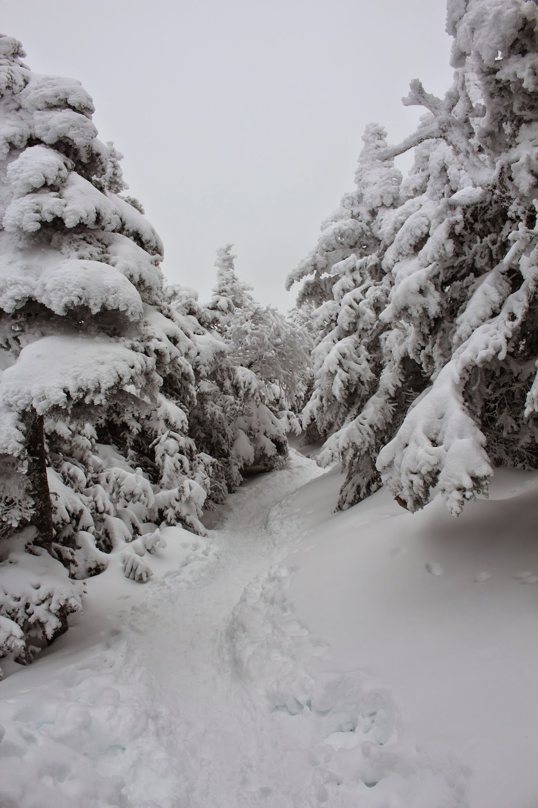
Muddy trail
that little rock bump in the middle is the buried summit cairn
I'm starting to understand the allure of winter hiking. I stepped onto the trail and the trees were heavy with snow, the sky was a luminous white, heavy with winter fog.
The temperature was a comfortable 27 degrees, no wind to speak of, quiet with a few hikers moving past after some pleasant conversation. It was a nice mix of hiking solo and feeling safe knowing others were on the trail. This was only my second solo 'winter' hike and it would test my ego.
The forecast indicated bright, sunny skies. When I asked a woman at the front desk of the Highland Center, she said, "...you want views? Come back in spring. You're not going to get them today."
Knowing I wouldn't find views on the summit, I took my time enjoying the mild temps, appreciating the beauty, making friends with gray jays, and revelling in the antics of chickadees and red squirrels.
I was wearing my Katoola microspikes thinking they wouldn't 'ball' as much as the Hillsound crampons. There was no difference. Both make snowballs under the feet. I felt like I was wearing Earth Shoes from the 70's.
At 3000 feet I decided to try out my new Tubbs Flex Alp snowshoes. They took a little getting used to but once I got them fitted correctly they were effortless to hike in!
As I approached the 4000 foot mark, I talked to a number of hikers coming down from the summit.
"No views"
"Blistering cold"
"White out conditions"
"I lost the trail a few times"
"Are you going to be okay? Do you have warmer clothes? It's cold up there."
As I emerged onto the treeless section of the trail, I was blinded by the white fog, white snow. It was a new, incredibly beautiful world. I stood there just staring, eyes watering, not from the cold but from awe.
I see a group of 6 hikers emerge from the white wall of fog... I talk to them about the remaining distance to the summit. They continue on and I watch them disappear.
I start to walk on knowing I am the last one on the mountain. Alone. Inexperienced in an alien world. I look at my GPS. I look behind me. I can no longer see the snowshoe trail of the hikers. I can't see their tracks ahead. The choice was easy; it wasn't worth the risk. I surrendered to the mountain. It was time to go down.
via Kedron Flume Trail, Ethan Pond Trail, Willey Range
Trail, (Mt. Willey), and back down...
I really wanted to hike up to Mount Pierce,
watch the sunrise, and possibly take a jaunt over to Eisenhower. I needed a relatively easy hike to ease me
back into winter hiking. When I told my
husband he said, “Why would you want to
do that? We’ve been to Pierce; it’s a
waste of a hike.” He kept bringing
it up until I changed my plans. I’m not
sure why he cared; he was home watching the football game.
I decided on Mt. Willey. It’s a steep little bugger of a mountain and
I found myself grumbling, sending imaginary darts at my husband’s head, in my mind.
I love wandering through the woods during winter but I don’t love winter mountain hiking. It’s more treacherous,
boring, and the rewards don’t come (at least not for me) until I reach the
higher elevations where trees start to look like Christmas cards. If it wasn’t for the hikers I met (Dan, Ralph
and Darrell) who distracted me from the monotonous, endless, ascent, I would
have turned back before I reached the summit.
I had on my new Hillsound Trail Crampons (http://hillsound.com/hillsound-product/trail-crampon/)
trying to determine if they were better than Kahtoola Microspikes. I ordered a size based on the fit of my
microspikes. Don’t do this.
The Kahtoola’s run small and the Hillsound’s run a
little larger. For example. I ordered a size Medium in the Kahtoola’s and
they were too tight for my winter hiking boots. A Large fits my boots perfectly. Based on that I ordered a Large (following
the size chart) of the Hillsound’s and they were too big. They looked like they fit okay until I started hiking on a steep incline and they started to slide around on the shoe. I read reviews that said they move around on
the shoe. However, I think it's more of a sizing issue than a product flaw. The other thing I noticed was the snowballing
on the metal plates. It wasn’t bad, a
couple of kicks against the other foot released the snow. At higher elevations
it wasn’t a problem since the snow was harder and less sticky.
The recent snow hid the narrow trail making it tricky to
follow in places, especially in the lower elevations. If you keep your mind focused, it shouldn’t be
too much of a problem. There is a
section of the Kedron trail that is pretty eroded with loose rocks, shale and
tree roots. Add running water and ice to the mix and it’s a challenge on the
descent. There are three water crossings, two small walk-overs and a larger one - the Kedron Flume. There are lovely views here. It’s worth the time to stop and take
photos. It was an easy walk across today, but may be an issue after heavy rains.
Kedron Flume on the way up. The falls go over a ledge - could be tricky crossing in the spring thaw.
I loved the infamous ladders! They are referred to as
ladders in blogs, but they are in-fact steep stairs. I wish there were more of them. I thought they were easy to ascend and
descend even with the few inches of snow. Once you finish hiking the stairs, your mind
will try to fool you into believing you are close to the summit. Nope…there is still another 800 feet (or
thereabouts) of elevation and it took me another 40 minutes before I reached
the summit.
Mountain-Forecast promised bright sunny skies in the
morning. I have lived in New England all
my life and it shouldn’t have been a surprise to emerge onto the outlook completely
engulfed by fog. As I
walked back to the trail I asked one of the other hikers where the actual
summit was, he pointed down to a small snow covered cairn. Haaa : ).
the view?
If you look carefully you can see Mt. Washington....not
Couldn't resist one more summit photo :) Eerily beautiful!
I set up the car for a car-camp and set off for the Baldface
Circle Trail parking area with the intention of hiking up to Eagle Crag and over to Mount
Meader in the morning.
the car
FYI there are some things you shouldn’t do when you car-camp
in November:
Take off your socks
Wear a short sleeve t-shirt
Or unzip your sleeping bag because you don’t
want feel like a stuffed sausage.
If you do these things you will wake up at 3 AM freezing but
too lazy to get up, put on your clothes, and zip up your sleeping bag. Instead you will roll yourself up in your
sleeping bag like a burrito.
I woke up at 6 AM tangled in my sleeping bag looking forward
to my thermos of hot coffee. Note to self: If you put hot coffee in a thermos
the night before, you will wake up to cold coffee. Sigh…No coffee, no sun, the clouds were thick, the air was cold
and damp. Change of plans. Not sure about the weather so I decided to be
safe and hike Eastman Mountain, saving Eagle Crag and Mount Meader for brighter
day.
I took the Baldface Circle Trail, Slippery Brook Trail, to
the Eastman Mountain Trail out and back.
It is the shortest round-trip route to the summit, only 8.2 miles. The trail is easy to follow with the
exception of a couple of areas of Slippery Brook where the leaves obscured the
trail making it a little tricky in spots.
Keep your eye on the yellow blazes, they will keep you on track. There are also some unexpected sections with deep
leaves just waiting for a turned ankle and a knee buckle.
deep leaves waiting for its next victim
There are five water crossings none will cause you any problems. Three are small walk overs and two are small rock hops. The trail ascends gradually until you reach mile two of the
Slippery Brook trail then it becomes a nice heart pumping ascent for about six-tenths of a mile until you reach the Eastman
Mountain trail. From here it is an easy
.8 trek to the summit. Even with the cloud cover it
was a beautiful summit.It would be a beautiful winter hike for those new to winter hiking.
Only nine 52WAVs to go.
Summit views
The trail
The ERD examining fresh bear scat
the only sun I saw all day
South Baldface view from the col
Summit selfie with the ERD who is only interested in lunch
I hiked today with my daughter’s best friend and her mom. My daughter abandoned us claiming too much
homework to join us. I knew nothing was
going to beat the brilliant blaze of colors on Iron Mountain last week, but the 360 views
on the rocky summit of South Moat came close.
There is some active timber harvesting at the start of the
trail. Look for a small arrow pointing
to the left of the clearing and follow the bright trail-marker ribbons leading
you around the harvesting back to the trail.
The recent rains left running water, wet leaves and slippery
rocks on the trail making it a little tricky in places. We all did a butt-thump at least once during the hike.
The people I hiked with today are good casual hikers. My daughter’s friend scurried up the trail
with ease. Her mom, who is not used to
the craggy New Hampshire trails, was cautious and a little hesitant but hiked at a steady clip.
Being a mostly solo hiker, I learned a couple of things on
today’s hike. A trail that is easy for
me to follow is not necessarily clear to other hikers. For example, if I see random branches laid
down across the trail, I know it’s a ‘heads up’ not to go that way. Hikers new to NH trails will walk over them
and keep going. I also learned I need to look behind me more
often to make sure fellow hikers are not far behind. Although I stop and wait every 5 minutes or
so, I should never let hikers get out of sight at any time (duh...Hiking 101). After stopping on the trail and waiting a few
minutes, I did not see or hear my friend and started to hike back up. She was fine but there was a fork in the
trail (I hadn’t noticed) and she didn’t know which way to turn. I could tell she was a little shaken thinking
she was going to get lost. It was a very
good lesson for me.
All and all, it was a great hike with great company,
stunning blue skies and a beautiful summit.
42 down 10 to go!
360 views on the South Moat Summit
The ERD and Copper at the bridge watercrossing
Pleurotus ostreatus - The Oyster Mushroom! Yum! I left some for the next hikers.
They are on the left side of the temporary trail (left of the clearing) at eye level.
Views of Chocorua and the Sisters from the trail
Views from the trail
Hanumanasana on summit rocks
My daughter's friend, her dog Copper and my chihuahua the ERD
the ERD at the summit
Summit views! It was beautiful, but WINDY and cold :). Not a day to bask on the rocks.
EPUD (eka pada urdhva dhanurasana) on the summit rocks
I thought about driving up the night before and car-camping at
the trailhead, but after reading numerous posts about the ‘very narrow’ and
‘steep’ condition of Iron Mountain Road, I was really worried about travelling on it at night. I decided to get up
early and drive to the trailhead. I woke up to my alarm, grabbed my gear (and the trusty
ERD) and was out of the house and ready for my 3 hour drive by 4:15AM.
Iron Mountain Road was much better than expected. It was a very well maintained, flat, smooth-graveled
road. Yes, the road is narrow but unless
you are driving a Mack truck, it’s not going to be a problem. I can see where it would be a little hairy if
you need to pass someone; however, there are two pullout areas along the road
and there are only a few occupied houses, so I don’t think passing cars is a
frequent occurrence.
If you are a fellow car-camper, the parking area is a nice
(large enough for 4-5 cars), seemingly safe place to spend the night. You also
have the bonus of waking up to an incredible view. As I walked through the field to the trail I
was surrounded by fall’s brilliant color palette, stunning mountain views and
the earthy sweet smell of fading ferns.
It felt like I was walking through a Van Gogh painting.
View in the field near the trailhead... a landscape waiting to be painted.
Many hiking logs indicate that the Iron Mountain Trail is a
very eroded, steep trail. One log said
some hikers turned back because it was too difficult. Yes the trail is eroded, but it isn’t a
difficult trail. Adding the South Cliffs without heading to
the iron mines, the trail is only 3.2 miles round trip and 3.6 miles if you add
the iron mines. I didn’t feel it was too steep; any steep
areas were offset by level ones. I do recommend
watching your step because of the numerous loose rocks now hidden under fallen
leaves. I would imagine in the spring with thawing snow and running water it would be quite an adventure to hike this trail. I took photos of the trail, so
you can judge for yourself.
I-would rate this hike on the easy side of moderate. I am not a trailblazing, red-lining, long
distance hiker. I am an intermediate,
slow-paced, photo-taking, meandering-What’s
book time?, kind of hiker. So I was
surprised at the ‘difficulty’ level most online logs rated this one. White Mountain Guide 28th Edition, Suggested hikes section (pg 72), contradicts this and gives it an Easy rating.
There are no blazes on the trail but the trail is easy to
follow. The fallen leaves bring peekaboo
trail views along the way to the summit.
There are no views at the summit, just the remains of the old fire tower
and piles of iron ore rocks (pretty cool).
There is a small handwritten sign pointing you in the direction of the south cliffs.
Continue past the summit for .6 miles. When you see a large boulder on the left of
the trail you are about 5 minutes away.
Take a left where a small cairn marks the way. This will lead you to the south cliffs rewarding
you with sweeping, unobstructed mountain views.
Amazing views for such a short hike. A highly recommended hike.
41 down, 11 to go.
The ERD scurrying around the ledges
Sweeping views and the ERD blending in with his surroundings
Foliage is not done yet! Best colors I've seen in years!
Oh human...why must you take so many photos...
Sleepy Hanumanasana
Bowing Hanumanasana
Remains of the old firetower at the summit of Iron mountain...no views but very interesting.
Piles of iron ore rocks all around
Lovely but inedible
Parking area for the trailhead. Room for 4 or 5 cars. My car (a Sequoia) on the left
Morning light on the South Cliffs
View coming down the trail back to the field to the car.
Striped maple (Acer pensylvanicum) also called moosewood. (thanks Keith & Jon for the ID)
Trailhead sign at the parking area
View from the field walking back to the parking area
Along Iron Mountain Road near the trailhead. I looked inside. Strangely enough it looks like an old post office!


